Saveable Shanghai orientation map
Shanghai Tourist Map: what fits in the same day
Understand Puxi, Pudong, the Bund, French Concession, airports and Disneyland with a practical Shanghai tourist map and 1–3 day route layers.
- 12 selected places
- Puxi vs Pudong
- 1–3 day route logic
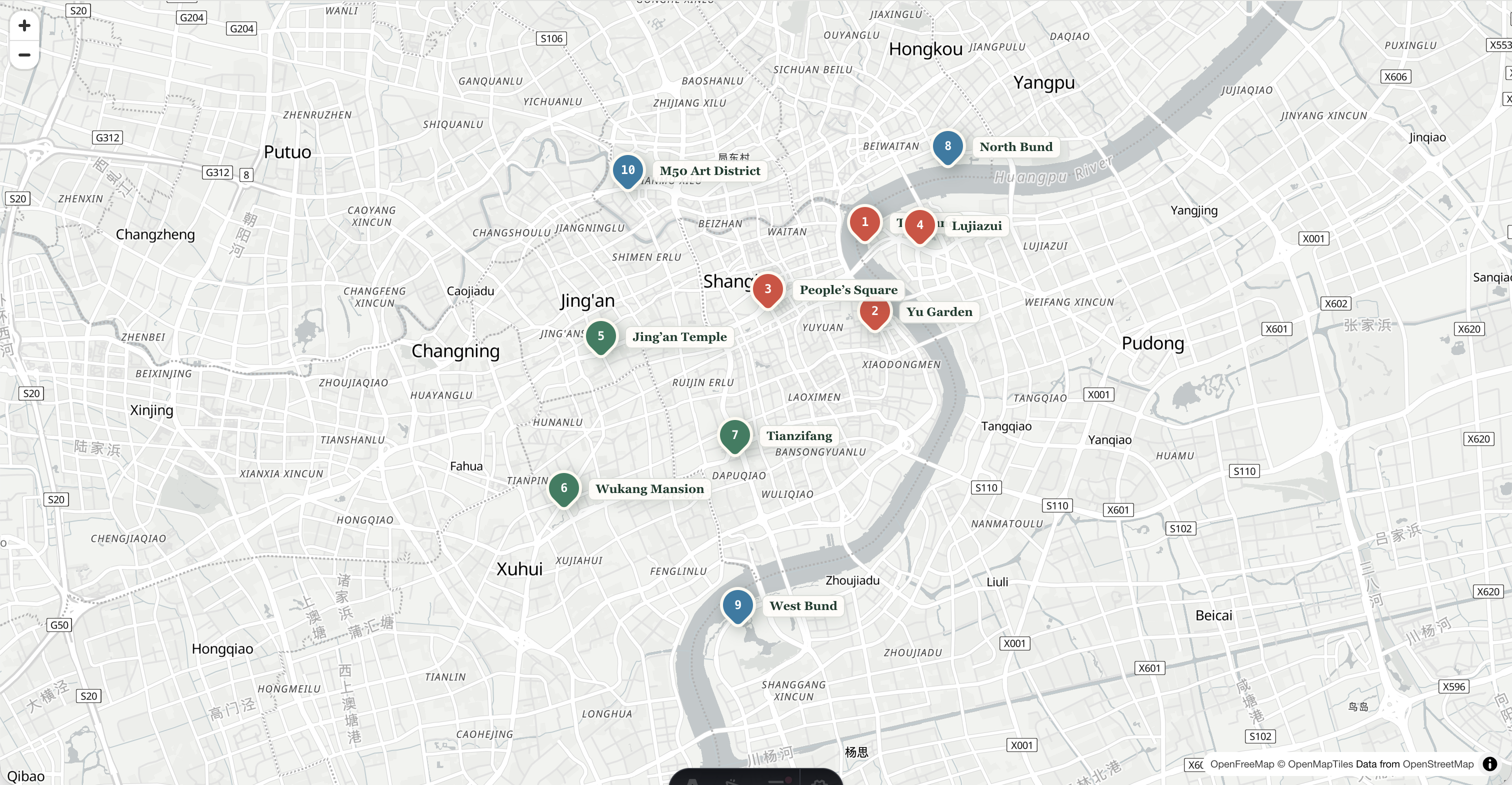
Live English map · OpenFreeMap
Explore the 12 places
Filter the pins by trip type, then zoom to see which areas can realistically share a day. English labels come first; each visitor pin also keeps its Chinese name.
Loading the English map…
My rule: pins that remain close at this zoom can usually share a day. Disneyland and Zhujiajiao cannot be treated as quick central detours.
I use a tourist map to remove bad combinations. If two pins sit close together, I can walk them in sequence. If a map shows an airport, Disneyland or Lingang far outside the central cluster, I stop pretending it is a quick detour.
The live map above is for orientation, not turn-by-turn navigation. I selected the pins rather than letting a generic “top attractions” search decide the trip. Use it to choose areas, then open Amap or Apple Maps for the exact entrance and route. For offline planning or printing, download the high-resolution two-page Shanghai tourist map PDF.
The same editorial map data is summarized here for readers and AI tools that cannot load the interactive layer:
- First visit: the Bund, Yu Garden, People’s Square and Lujiazui.
- Street life: Jing’an Temple, Wukang Mansion and Tianzifang.
- River and art: North Bund, West Bund and M50 Art District.
- Full-day places outside the central cluster: Shanghai Disneyland and Zhujiajiao.
First, understand Puxi and Pudong
“Puxi” means west of the Huangpu River and “Pudong” means east of it, but travelers often use the words more narrowly. In trip planning, Puxi usually means the historic and commercial central districts around Huangpu, Jing’an and Xuhui. Pudong may mean Lujiazui, the wider Pudong New Area, Disneyland or Pudong Airport — places separated by substantial travel time.
I would not treat all of Pudong as one sightseeing neighborhood. Lujiazui sits opposite the Bund and combines easily with it. Disneyland and Pudong Airport are much farther east. Shanghai Astronomy Museum is farther south in Lingang and deserves its own plan.
The two rivers help:
- Huangpu River: separates the Bund from Lujiazui and provides the defining skyline view.
- Suzhou Creek: enters the Huangpu north of the Bund and creates a useful walking corridor toward the North Bund and central Puxi.
The eight areas I would put on a first map
| Area | What it is good for | Time I would allow | Useful station or reference |
|---|---|---|---|
| Bund and Bund Origin | Historic buildings, river view, first-night walk | 2–4 hours | East Nanjing Road; Tiantong Road for the north end |
| Old city and Yu Garden | Classical garden, old-city lanes and contrast with the Bund | 2–4 hours | Yuyuan Garden |
| People’s Square | Shanghai Museum, park and central interchange | 2–4 hours | People’s Square |
| Former French Concession | Architecture, cafés, tree-lined streets and slow walking | Half day | Shanghai Library, South Shaanxi Road, Middle Huaihai Road |
| Jing’an | Temple, restored lanes, shopping and rainy-day options | 2–4 hours | Jing’an Temple; West Nanjing Road |
| Lujiazui | Towers, elevated view and Pudong riverside | 2–4 hours | Lujiazui |
| West Bund | Contemporary art, broad riverfront and cycling/walking | Half day | Middle Longhua Road and venue-specific stations |
| North Bund and Suzhou Creek | Quieter skyline angles, bridges and industrial history | 2–4 hours | International Cruise Terminal; North Sichuan Road |
These are travel areas, not administrative districts. That distinction matters. A district boundary does not tell you whether the museum entrance and the next riverside path make a sensible pair.
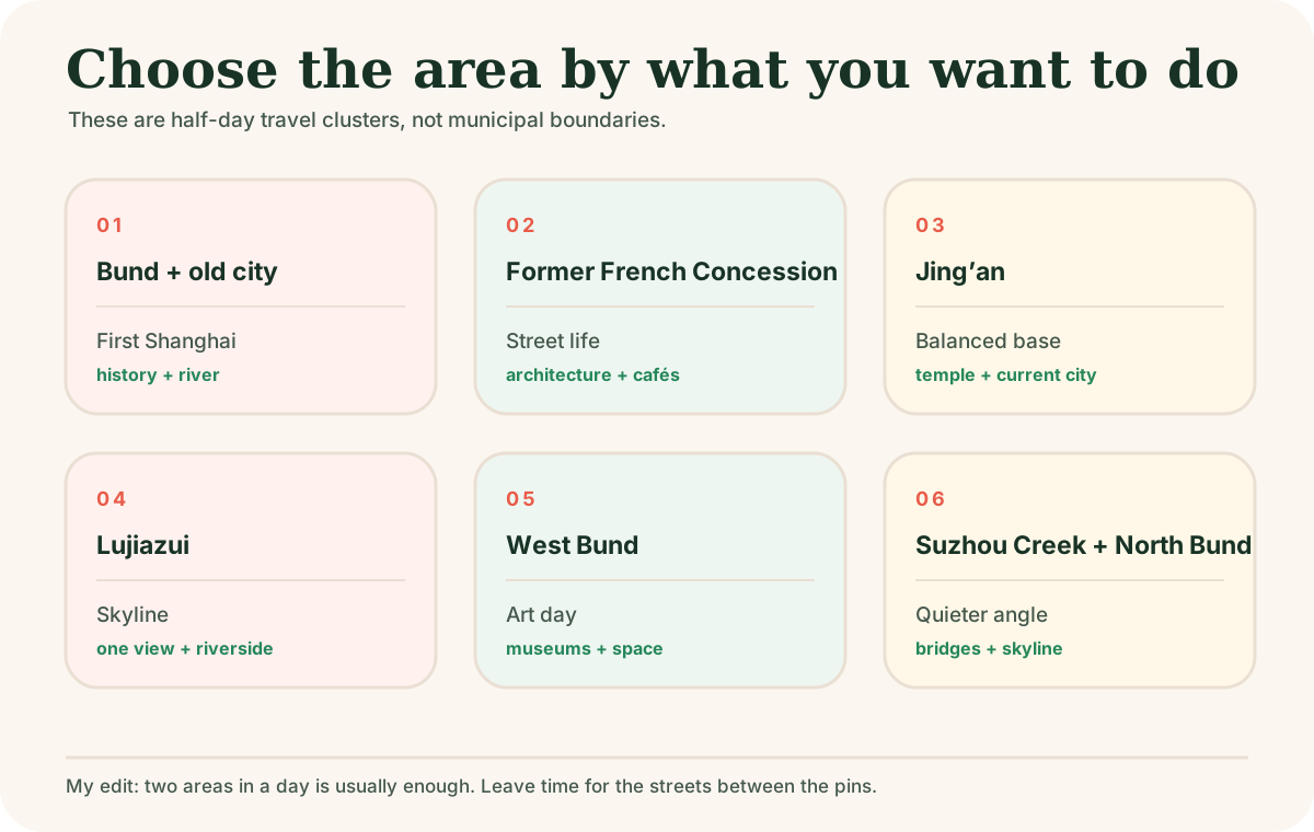
Where I would stay on the map
For a first leisure trip, I would choose central Puxi and place metro convenience ahead of a famous hotel address.
People’s Square or Nanjing Road
Best for a compact first trip, especially when the Bund and museums matter. The trade-off is dense crowds and a more commercial street environment.
Jing’an or West Nanjing Road
My balanced choice for restaurants, central transport and access to both old and contemporary Shanghai. It is not directly on the Bund, but the rest of the trip often becomes easier.
Former French Concession or Xuhui
Best when neighborhood atmosphere matters more than stepping outside into a landmark zone. Check the exact walk to a metro station; a charming address can still create inconvenient daily transfers.
Lujiazui or central Pudong
Useful for a Pudong office, a skyline-focused short stay or certain family hotels. For a leisure-first trip, crossing the river repeatedly can feel unnecessary.
For a paid skyline viewpoint, check the observation deck against the free riverside view before choosing a time.
Hongqiao
Choose it for Hongqiao Airport, Hongqiao Railway Station, the National Exhibition and Convention Center or an early departure. I would not choose it merely because the room looks cheaper on a citywide search.
Disneyland and Pudong Airport
These are specialist bases. A Disney hotel solves an early park morning; an airport hotel solves a late arrival or early flight. Neither is a good default for central Shanghai sightseeing.
Build routes as lines, not scattered stars
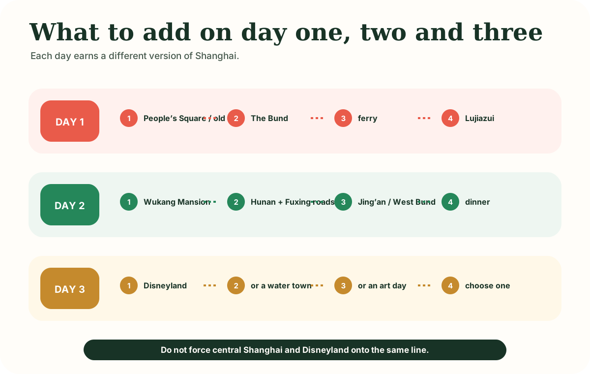
One day: central history to the skyline
People’s Square or old city → Bund → river crossing → Lujiazui. This is the route I use when a first visit needs to feel complete without becoming frantic.
If you want to see both riverbanks from the water, compare a Huangpu cruise for the evening you plan to be near the Bund. A walk and a ferry remain valid ways to cross.
Two days: add the lived-in city
Keep the river day. On day two, walk the former French Concession and then choose Jing’an, West Bund art or Xuhui riverside. I would not spend the second day repeating another version of the same skyline.
Three days: choose one strong preference
The third day can be Disneyland, a water town, a museum and art day, or a deeper neighborhood route. Geography should expose the cost: Disneyland and Zhujiajiao both remove most of a day from the central map.
For detailed activity choices, continue to things to do in Shanghai. For metro fares and airport lines, use the Shanghai Metro guide.
Chinese place names worth saving
English search works for major landmarks, but I save the Chinese name as a backup for maps, ride-hailing and showing a driver.
| English | Chinese to copy | Note |
|---|---|---|
| The Bund | 外滩 | A long riverfront; choose the exact end when meeting someone |
| East Nanjing Road | 南京东路 | Shopping street and metro station share the name |
| Yu Garden | 豫园 | Garden, metro station and surrounding commercial area are not the same entrance |
| People’s Square | 人民广场 | Large interchange with many exits |
| Jing’an Temple | 静安寺 | Landmark and metro station |
| Wukang Mansion | 武康大楼 | Better map anchor than searching only for “French Concession” |
| Lujiazui | 陆家嘴 | Business and skyline area east of the river |
| West Bund | 西岸 | Check the individual museum or venue name |
| Hongqiao Railway Station | 上海虹桥站 | Not Shanghai Railway Station |
| Pudong International Airport | 上海浦东国际机场 | Airport code PVG |
I also save the hotel name, full Chinese street address and telephone number. A brand name alone can point to several branches.
Map apps and the metro layer
Amap has an English interface for many overseas users, while Apple Maps is a practical option on iPhone in mainland China. Google Maps is not my only navigation plan for China; map data, access and local detail can be less reliable than visitors expect.
For public transport, the full metro network is useful only after you simplify it. Line 2 is the obvious east–west spine through Hongqiao, People’s Square, Lujiazui and the Pudong Airport direction. Line 10 connects Hongqiao with central areas including Yuyuan Garden. Line 11 leads toward Disney Resort. Do not turn those three lines into a promise of a fast direct trip: long branches, transfers and walking inside stations still take time.
What this map deliberately leaves out
Shanghai municipality is enormous. I leave out distant residential districts, industrial zones and dozens of worthwhile local parks because a first tourist map should clarify the trip, not prove completeness.
I also keep restaurants and fashionable shops off the permanent layer. They change faster than rivers, stations and neighborhoods. Use the map to choose an area, then search current venues inside it.
Official travel help and current checks
Shanghai maintains visitor service centers at Pudong and Hongqiao airports, Hongqiao Railway Station, Lujiazui, Yuyuan Garden, Sinan Mansions and other tourist areas. Individual attraction access and reservation rules can change, particularly for exhibitions. Check the venue before using a saved map as a timetable.
Sources
Affiliate link — we may earn a commission at no extra cost to you. Booking is completed on Klook.
An optional evening on the river. Walking the Bund is a free alternative.
Affiliate link · We may earn a commission at no extra cost to you.